File:Saharan Africa regions map.png
預覽大小:800 × 460 像素。 其他解析度:320 × 184 像素 | 640 × 368 像素 | 1,024 × 588 像素 | 1,280 × 735 像素 | 2,000 × 1,149 像素。
原始檔案 (2,000 × 1,149 像素,檔案大小:528 KB,MIME 類型:image/png)
摘要
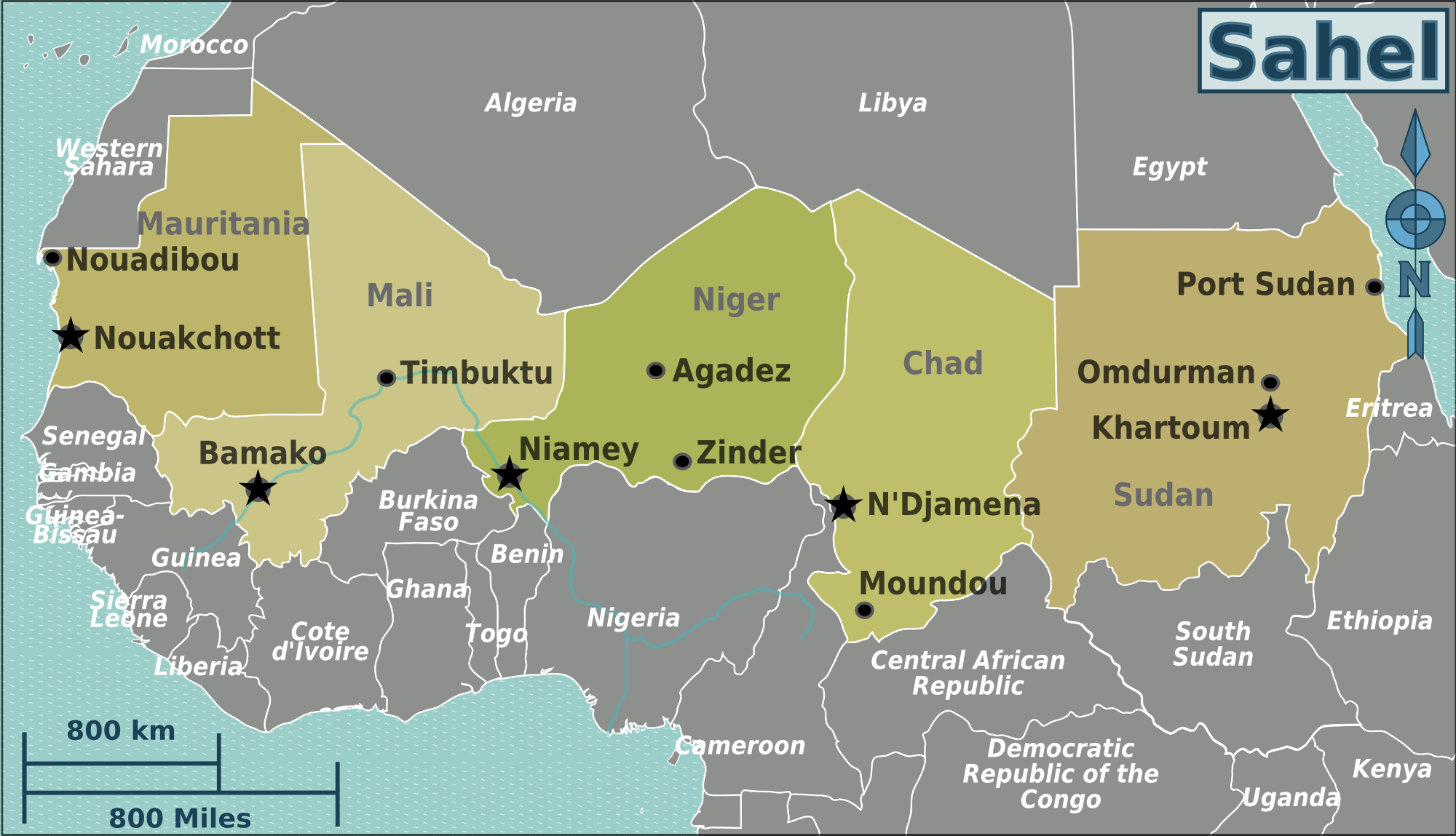
| 描述 | Map of Saharan Africa for use on Wikivoyage, English version |
| 日期 | |
| 來源 | 自己的作品 based on the blank worldmap |
| 作者 | Peter Fitzgerald, amendments by LtPowers |
| 其他版本 |
.png)
.png)
.png)
授權條款
此檔案採用創用CC 姓名標示-相同方式分享 3.0 未在地化版本授權條款。
- 您可以自由:
- 分享 – 複製、發佈和傳播本作品
- 重新修改 – 創作演繹作品
- 惟需遵照下列條件:
- 姓名標示 – 您必須指名出正確的製作者,和提供授權條款的連結,以及表示是否有對內容上做出變更。您可以用任何合理的方式來行動,但不得以任何方式表明授權條款是對您許可或是由您所使用。
- 相同方式分享 – 如果您利用本素材進行再混合、轉換或創作,您必須基於如同原先的相同或兼容的條款,來分布您的貢獻成品。
原始上傳日誌
| This file was imported from Wikivoyage WTS. |
The original description page was here. All following user names refer to wts.wikivoyage-old.
- 2008-08-10 04:01 (WT-shared) Peterfitzgerald archive copy at the Wayback Machine 3008×1731 (809780 bytes) {{Imagecredit|credit=Peter Fitzgerald|captureDate=9 August 2008|location=Africa|source=[[:Image:Saharan Africa regions map.svg]]|caption=Afr (Import from wikitravel.org/shared)
- 2008-08-12 20:31 (WT-shared) Peterfitzgerald archive copy at the Wayback Machine 3008×1731 (809780 bytes) {{Imagecredit|credit=Peter Fitzgerald|captureDate=12 August 2008|location=Africa|source=[[:Image:West Africa regions map.svg]]|caption=Afric (Import from wikitravel.org/shared)
- 2008-08-12 20:33 (WT-shared) Peterfitzgerald archive copy at the Wayback Machine 3008×1731 (809780 bytes) Reverted to version as of 04:01, 10 August 2008 (Import from wikitravel.org/shared)
- 2010-01-29 21:55 (WT-shared) Peterfitzgerald archive copy at the Wayback Machine 3399×1953 (971572 bytes) Saharan Africa -> Sahel, per talk (Import from wikitravel.org/shared)
- 2011-07-22 05:52 (WT-shared) Burmesedays[失效連結] 2000×1149 (545411 bytes) minus South Sudan (Import from wikitravel.org/shared)
- 2011-07-22 13:37 (WT-shared) LtPowers[失效連結] 2000×1149 (464970 bytes) Remove Juba, re-arrange text slightly for aesthetics, fix capital city stars (Import from wikitravel.org/shared)
- 2011-07-22 13:39 (WT-shared) LtPowers[失效連結] 2000×1149 (540406 bytes) Adjust document "page" location to match the framing of the map. (Import from wikitravel.org/shared)
檔案歷史
點選日期/時間以檢視該時間的檔案版本。
| 日期/時間 | 縮圖 | 尺寸 | 使用者 | 備註 | |
|---|---|---|---|---|---|
| 目前 | 2012年12月19日 (三) 13:02 | | 2,000 × 1,149(528 KB) | OgreBot | (BOT): Reverting to most recent version before archival |
| 2012年12月19日 (三) 13:02 |  | 2,000 × 1,149(454 KB) | OgreBot | (BOT): Uploading old version of file from wts.wikivoyage; originally uploaded on 2011-07-22 13:37:07 by (WT-shared) LtPowers | |
| 2012年12月19日 (三) 13:02 |  | 2,000 × 1,149(533 KB) | OgreBot | (BOT): Uploading old version of file from wts.wikivoyage; originally uploaded on 2011-07-22 05:52:57 by (WT-shared) Burmesedays | |
| 2012年12月19日 (三) 13:01 |  | 3,399 × 1,953(949 KB) | OgreBot | (BOT): Uploading old version of file from wts.wikivoyage; originally uploaded on 2010-01-29 21:55:21 by (WT-shared) Peterfitzgerald | |
| 2012年12月19日 (三) 13:01 |  | 3,008 × 1,731(791 KB) | OgreBot | (BOT): Uploading old version of file from wts.wikivoyage; originally uploaded on 2008-08-10 04:01:29 by (WT-shared) Peterfitzgerald | |
| 2012年11月18日 (日) 10:21 |  | 2,000 × 1,149(528 KB) | MGA73bot2 | {{BotMoveToCommons|wts.oldwikivoyage|year={{subst:CURRENTYEAR}}|month={{subst:CURRENTMONTHNAME}}|day={{subst:CURRENTDAY}}}} == {{int:filedesc}} == {{Information |description=Africa regions map. , Saharan Africa * Map of: Saharan Africa¤ |date=9 August... |
檔案用途
下列頁面有用到此檔案:
全域檔案使用狀況
以下其他 wiki 使用了這個檔案:
- de.wikivoyage.org 的使用狀況
- el.wikivoyage.org 的使用狀況
- en.wikivoyage.org 的使用狀況
- fa.wikivoyage.org 的使用狀況
- fi.wikivoyage.org 的使用狀況
- he.wikivoyage.org 的使用狀況
- incubator.wikimedia.org 的使用狀況
- it.wikivoyage.org 的使用狀況
- ja.wikivoyage.org 的使用狀況
- nl.wikivoyage.org 的使用狀況
- pl.wikivoyage.org 的使用狀況
- pt.wikivoyage.org 的使用狀況
- ru.wikivoyage.org 的使用狀況