File:Îles d'Hyères topographic map-fr.svg

此 SVG 檔案的 PNG 預覽的大小:784 × 337 像素。 其他解析度:320 × 138 像素 | 640 × 275 像素 | 1,024 × 440 像素 | 1,280 × 550 像素 | 2,560 × 1,100 像素。
原始檔案 (SVG 檔案,表面大小:784 × 337 像素,檔案大小:1.84 MB)
摘要
| 拍攝地點 | | 位於此地的本圖片與其他圖片: OpenStreetMap |
|---|
| 描述 |
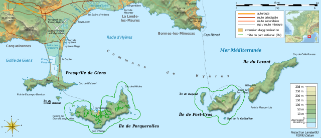
Français : Carte topographique et administrative en français des Îles d'Hyères.
Deutsch: Topographische Karte / Verwaltungskarte zum Îles d'Hyères, in Französische
English: Topographic and administrative map in French language of Îles d'Hyères
Italiano: Carta topografica e amministrativa delle Isole di Hyères (en francese)
|
||
| 日期 | (UTC) | ||
| 來源 |
Création personnelle ;
|
||
| 作者 | Bourrichon (talk) - fr:Bourrichon | ||
| 授權許可 (重用此檔案) |
|
||
| 其他版本 |
Add-your-version : Template:Other versions/Îles d'Hyères map
|


|
This SVG file contains embedded text that can be translated into your language, using any capable SVG editor, text editor or the SVG Translate tool. For more information see: About translating SVG files. |
本vector image使用Inkscape創作 .
授權條款
我,本作品的著作權持有者,決定用以下授權條款發佈本作品:

|
已授權您依據自由軟體基金會發行的無固定段落、封面文字和封底文字GNU自由文件授權條款1.2版或任意後續版本,對本檔進行複製、傳播和/或修改。該協議的副本列在GNU自由文件授權條款中。 |
您可以選擇您需要的授權條款。
檔案歷史
點選日期/時間以檢視該時間的檔案版本。
| 日期/時間 | 縮圖 | 尺寸 | 使用者 | 備註 | |
|---|---|---|---|---|---|
| 目前 | 2018年8月23日 (四) 19:40 | | 784 × 337(1.84 MB) | Bourrichon | +extension des limites du parc national : ajout de l'île de Porquerolles |
| 2011年8月19日 (五) 21:53 |  | 784 × 337(1.83 MB) | Bourrichon | == {{int:filedesc}} == {{Location|20|15|00|S|57|35|00|E|scale:500000}} {{Information |Description= {{fr|Carte topographique et administrative en français des Îles d'Hyères.}} {{de|Topographische Karte / Verwaltungskarte zum [[: |
檔案用途
下列頁面有用到此檔案:
全域檔案使用狀況
以下其他 wiki 使用了這個檔案:
- cs.wikipedia.org 的使用狀況
- da.wikipedia.org 的使用狀況
- de.wikipedia.org 的使用狀況
- en.wikipedia.org 的使用狀況
- en.wikivoyage.org 的使用狀況
- fr.wikipedia.org 的使用狀況
- Conservatoire du littoral
- Parc national de Port-Cros
- Presqu'île de Giens
- Îles d'Hyères
- Utilisateur:Flappiefh/Bac à sable/Images à améliorer/Contenu visiteur
- Wikipédia:Atelier graphique/Cartes/Archives/septembre 2011
- Rade d'Hyères
- Wikipédia:Atelier graphique/Cartes/Archives/octobre 2016
- Golfe de Giens
- fr.wiktionary.org 的使用狀況
- ja.wikipedia.org 的使用狀況
- la.wikipedia.org 的使用狀況
- nn.wikipedia.org 的使用狀況
- oc.wikipedia.org 的使用狀況
- pl.wikipedia.org 的使用狀況
- pt.wikipedia.org 的使用狀況
- ru.wikipedia.org 的使用狀況
- www.wikidata.org 的使用狀況
- zh.wikipedia.org 的使用狀況