File:Map German SpeakingWorld.png

預覽大小:800 × 370 像素。 其他解析度:320 × 148 像素 | 640 × 296 像素 | 1,357 × 628 像素。
原始檔案 (1,357 × 628 像素,檔案大小:36 KB,MIME 類型:image/png)

|
File:Legal statuses of German in the world.svg是本檔案的向量版本。 如果品質不低,就應該優先使用該檔案,而非PNG檔案。
File:Map German SpeakingWorld.png → File:Legal statuses of German in the world.svg
更多資訊請參閱Help:SVG/zh。 |
 |
| 描述 |
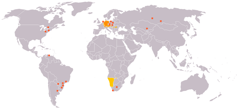
English: Legend:
Deutsch: Legende:
Français : Carte du monde où on parle l'allemand.
עברית:
Italiano: Legenda:
Nederlands: Beschrijving:
Svenska: Beskrivning:
|
||||||||
| 來源 | en:Image:Map_German_World.png | ||||||||
| 作者 | en:User:Ilario. | ||||||||
| 授權許可 (重用此檔案) |
我,本作品的著作權持有者,決定用以下授權條款發佈本作品:
您可以選擇您需要的授權條款。 |
||||||||
| 其他版本 | File is obsolete! Use File:Legal statuses of German in the world.svg instead. |

檔案歷史
點選日期/時間以檢視該時間的檔案版本。
| 日期/時間 | 縮圖 | 尺寸 | 使用者 | 備註 | |
|---|---|---|---|---|---|
| 目前 | 2020年7月19日 (日) 04:35 | | 1,357 × 628(36 KB) | Maphobbyist | South Sudan and Montenegro borders |
| 2007年11月11日 (日) 17:14 |  | 1,357 × 628(46 KB) | Domaleixo | ||
| 2006年7月28日 (五) 02:28 |  | 1,357 × 628(25 KB) | Cwlq~commonswiki | ||
| 2006年6月28日 (三) 14:18 |  | 1,357 × 628(37 KB) | Highpriority | {{Information |Description=en: Legend: *Orange: native language *Gold: Secondary language or non-official. *Red-orange square: German minorities de: Legende: *dunkles Orange: Amtssprache/Muttersprache *helles Orange: Zweitsprache oder nicht offiziel |
檔案用途
沒有使用此檔案的頁面。
全域檔案使用狀況
以下其他 wiki 使用了這個檔案:
- de.wikipedia.org 的使用狀況
- fr.wikipedia.org 的使用狀況
- incubator.wikimedia.org 的使用狀況