File:Map of the Canary Islands.svg

此SVG文件的PNG预览的大小:800 × 355像素。 其他分辨率:320 × 142像素 | 640 × 284像素 | 1,024 × 455像素 | 1,280 × 569像素 | 2,560 × 1,137像素 | 3,152 × 1,400像素。
原始文件 (SVG文件,尺寸为3,152 × 1,400像素,文件大小:835 KB)
摘要
| 描述 |
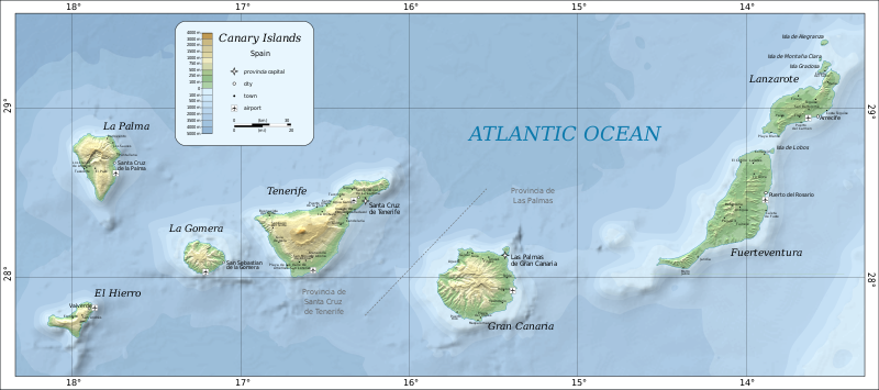
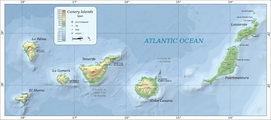
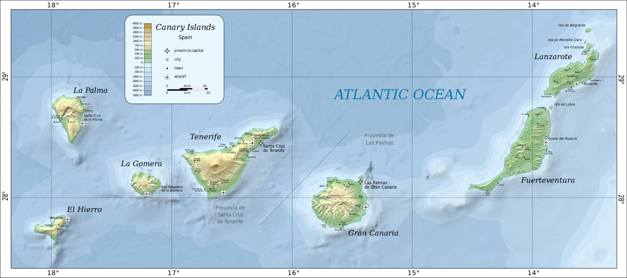
Deutsch: Karte der Kanarischen Inseln auf Englisch English: Map of the Canary Islands. Magyar: A Kanári-szigetek térképe Română: Harta Insulelor Canare. |
| 日期 | |
| 来源 | Self-made in Inkscape by w:User:Mysid. Based on SRTM data as edited by CGIAR-CSI. Place names based on the Open Streetmap. |
| 作者 | Oona Räisänen (Mysid) |
| 其他版本 |
|


许可协议
| 本作品已被作者英语维基百科的Mysid释出到公有领域。这适用于全世界。 在一些国家这可能不合法;如果是这样的话,那么: Mysid无条件地授予任何人以任何目的使用本作品的权利,除非这些条件是法律规定所必需的。 |

|
此SVG檔案包含可翻譯至您的語言的内嵌文字,可以使用任何可用SVG編輯器、文本編輯器或SVG翻譯工具來翻譯。詳情請見:關於翻譯SVG檔案。 |
文件历史
点击某个日期/时间查看对应时刻的文件。
| 日期/时间 | 缩略图 | 大小 | 用户 | 备注 | |
|---|---|---|---|---|---|
| 当前 | 2020年6月26日 (五) 22:57 | | 3,152 × 1,400(835 KB) | Gaja | fixed and supplemented place names, some error correction |
| 2010年8月10日 (二) 07:31 |  | 3,152 × 1,400(828 KB) | Mysid | bathymetry experiment | |
| 2010年8月6日 (五) 01:00 |  | 3,152 × 1,400(736 KB) | Mysid | fonts | |
| 2010年8月6日 (五) 00:56 |  | 3,152 × 1,400(733 KB) | Mysid | updated with better data sources | |
| 2009年1月22日 (四) 05:49 |  | 776 × 399(274 KB) | Mysid | revised fonts | |
| 2009年1月17日 (六) 04:59 |  | 776 × 399(274 KB) | Mysid | resizing embedded png | |
| 2009年1月5日 (一) 21:13 |  | 776 × 399(225 KB) | Mysid | major improvements | |
| 2007年8月2日 (四) 07:16 |  | 734 × 355(27 KB) | Mysid | {{Information |Description=Map of the Canary Islands. |Source=SVG drawn in Inkscape by Mysid; based on a JPEG (en:Image:Canary-map.jpg) originally compiled from a NASA source by Montrealais. |Date=August 2, 2007 |Author= [[w: |
文件用途
以下页面使用本文件:
全域文件用途
以下其他wiki使用此文件:
- ar.wikipedia.org上的用途
- ast.wikipedia.org上的用途
- az.wikipedia.org上的用途
- be-tarask.wikipedia.org上的用途
- bg.wikipedia.org上的用途
- bn.wikipedia.org上的用途
- cs.wikipedia.org上的用途
- da.wikipedia.org上的用途
- de.wikipedia.org上的用途
- de.wikivoyage.org上的用途
- el.wikipedia.org上的用途
- el.wikivoyage.org上的用途
- en.wikipedia.org上的用途
- es.wikipedia.org上的用途
- eu.wikipedia.org上的用途
- fi.wikipedia.org上的用途
- fr.wikipedia.org上的用途
- fy.wikipedia.org上的用途
- id.wikipedia.org上的用途
- is.wikipedia.org上的用途
- it.wikivoyage.org上的用途
- kbd.wikipedia.org上的用途
- lb.wikipedia.org上的用途
- lt.wikipedia.org上的用途
- mn.wikipedia.org上的用途
- nl.wikipedia.org上的用途
- nn.wikipedia.org上的用途
- no.wikipedia.org上的用途
- pl.wikipedia.org上的用途
- pl.wikivoyage.org上的用途
- ru.wikipedia.org上的用途
- sc.wikipedia.org上的用途
- sl.wikipedia.org上的用途
- sv.wikivoyage.org上的用途
- te.wikipedia.org上的用途
- tt.wikipedia.org上的用途
- uk.wikipedia.org上的用途
查看本文件的更多全域用途。