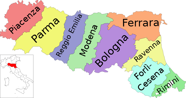
File:Map of region of Emilia-Romagna, Italy, with provinces-it.svg

此SVG文件的PNG预览的大小:800 × 422像素。 其他分辨率:320 × 169像素 | 640 × 337像素 | 1,024 × 540像素 | 1,280 × 675像素 | 2,560 × 1,349像素 | 4,800 × 2,530像素。
原始文件 (SVG文件,尺寸为4,800 × 2,530像素,文件大小:186 KB)
摘要
| 描述 | (Italian version) |
| 日期 | |
| 来源 | 自己的作品 |
| 作者 | Vonvikken |
| 其他版本 |
    |


W3C-validity not checked.

|
This SVG file contains embedded text that can be translated into your language, using any capable SVG editor, text editor or the SVG Translate tool. For more information see: About translating SVG files. |
许可协议
| 本作品已被作者Vonvikken释出到公有领域。这适用于全世界。 在一些国家这可能不合法;如果是这样的话,那么: |
文件历史
点击某个日期/时间查看对应时刻的文件。
| 日期/时间 | 缩略图 | 大小 | 用户 | 备注 | |
|---|---|---|---|---|---|
| 当前 | 2023年9月19日 (二) 14:19 | | 4,800 × 2,530(186 KB) | Quetz72 | File uploaded using svgtranslate tool (https://svgtranslate.toolforge.org/). Added translation for ca. |
| 2022年10月7日 (五) 10:04 |  | 4,800 × 2,530(186 KB) | Krepideia | Borders update: migration of the Municipalities of Montecopiolo and Sassofeltrio into the province of Rimini (2021) | |
| 2010年9月16日 (四) 07:31 |  | 4,800 × 2,530(186 KB) | Vonvikken | +Minimap | |
| 2010年9月16日 (四) 06:26 |  | 4,800 × 2,530(151 KB) | Vonvikken | == {{int:filedesc}} == {{Information |Description={{DescrMapRegionItaly|EMI|Italian}} |Source={{own}} |Author=Vonvikken |Date=2010-09-16 |Permission= |other_versions=100px|Blank[[File: |
文件用途
以下页面使用本文件:
全域文件用途
以下其他wiki使用此文件:
- an.wikipedia.org上的用途
- ar.wikipedia.org上的用途
- bg.wikipedia.org上的用途
- ca.wikipedia.org上的用途
- cs.wikipedia.org上的用途
- cy.wikipedia.org上的用途
- da.wikipedia.org上的用途
- de.wikipedia.org上的用途
- en.wikipedia.org上的用途
- Tiber
- Emilia-Romagna
- Provinces of Italy
- Province of Reggio Emilia
- Province of Bologna
- Province of Ferrara
- Province of Forlì-Cesena
- Province of Modena
- Province of Parma
- Province of Piacenza
- Province of Ravenna
- Category:Emilia-Romagna
- Province of Rimini
- Template:Emilia–Romagna
- Metropolitan City of Bologna
- List of municipalities of Emilia-Romagna
- Flag of Emilia-Romagna
- Altedo
- Monte Battaglia
- Citadel of Parma
- es.wikipedia.org上的用途
- et.wikipedia.org上的用途
- fi.wikipedia.org上的用途
- ga.wikipedia.org上的用途
- hu.wikipedia.org上的用途
- incubator.wikimedia.org上的用途
- it.wikipedia.org上的用途
- it.wikibooks.org上的用途
查看本文件的更多全域用途。